Betterview is the Property Intelligence & Risk Management Solution the insurance industry depends on to identify and mitigate property risk, improve underwriting and inspection efficiency, and build a more transparent customer experience.
With over 2,000 property datapoints and pre-filed peril scores optimized for pricing, provide accurate direct-to-consumer quotes with minimal-to-no IT lift.
Direct API connection for rating
Widely accepted rating variables
More accurately price and avoid risk
New Business Underwriting
Instant clarity on every property
Improve underwriting speed and accuracy by automating inspections, straight-through-processing solid risks, and drilling down on properties that need attention.
Automate and accelerate workflows
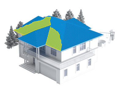
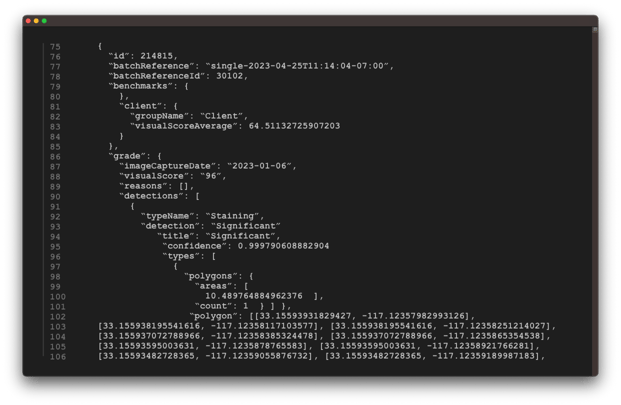
All your COPE data in one place
Virtualize Loss Control
Existing Business Renewals
Continuously monitor property condition
Using automated change detections and an archive of historical imagery, see how properties change over time, avoiding surprises at time of renewal.
Get notified about property changes
Respond to changing conditions
Always get the right rate
Claims
Streamline your claims experience
Accurately and rapidly respond to claims with a complete view of near-real-time property condition, confidently responding to legitimate losses and mitigating fraudulent claims.
Know before FNOL
Speed recovery
Reduce fraud
Customer Perspectives
Cincinnati Insurance
EMC Insurance
West Bend Mutual
Industry Leaders Trust Betterview
Lines of Business
Homeowners
Automate inspection and underwriting process by quickly identifying low-risk homes. Strategically inspect high-risk properties virtually, avoiding costly inspections. Provide instant and accurate quotes while saving millions in operational costs.
High-Value Homes
Identify unique features like tennis courts, stables, detached garages, or complex roof structures. Confidently price and write high-value policies while providing the best Customer Service to policyholders conditioned to exceptional interactions.
Farmowners
Know a farmhouse’s exposure to perils such as fire, windstorm, hail, and quickly validate the replacement cost. Identify additional structures like barns, silos, stables, sheds, and heavy equipment to set appropriate coverage limits.
Business Owners Policies (BOP)
Discover the risk associated with a business such as roof condition, crime in the neighborhood, business data, and peril exposure risk. Reveal building survivability, replacement costs, and potential business interruption.
Middle Market Commercial
Inspect individual buildings on a large property to determine the health of the total policy. Look at peril risks, property attributes detected by computer vision, and the 3D views of the property to provide accurate pricing and policy terms.
Excess & Surplus (E&S)
When insuring unique high-risk properties and dealing with tighter regulations, understanding a policy’s current and future risks is crucial in reducing losses with integrated partner insights and ensuring ongoing stability through continuous monitoring.
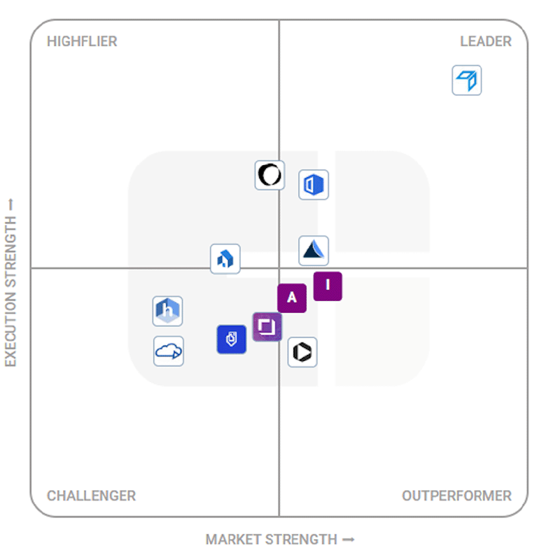
Betterview Recognized as Market Leader
CB Insights has named Betterview the market leader in virtual property appraisals for insurers needing to accurately assess the condition and risk of properties.
with Betterview’s Property Intelligence & Risk Management Solution. Identify and mitigate risks, automate pricing and underwriting, and transform your property insurance from Repair-and-Replace to Predict-and-Prevent. Contact us today to learn more.